![](/images/other/stat-length.png)
![Trail Walking Rémalard en Perche - Voie Verte Rémalard - Bois St Georges 6Km - Photo](https://media.geolcdn.com/t/1900/400/ext.pjpeg?maxdim=2&url=https%3A%2F%2Fstatic1.geolcdn.com%2Fsiteimages%2Fupload%2Ffiles%2F1553511878bg_sport_marche.png)
Voie Verte Rémalard - Bois St Georges 6Km
ODDAD78
User
![Length](/images/other/stat-length.png)
![Max alt](https://static1.geolcdn.com/siteimages/upload/files/1508320355ic_sort_altitude_max_24dp.png)
![Uphill gradient](https://static1.geolcdn.com/siteimages/upload/files/1508320355ic_sort_den_pos_24dp.png)
![Km-Effort](/images/other/stat-length.png)
![Min alt](https://static1.geolcdn.com/siteimages/upload/files/1508320355ic_sort_altitude_min_24dp.png)
![Downhill gradient](https://static1.geolcdn.com/siteimages/upload/files/1508320355ic_sort_den_neg_24dp.png)
![Boucle](https://static1.geolcdn.com/siteimages/upload/files/16400158638029165_repeat_loop_refresh_sync_direction_icon.png)
![Walking](https://static1.geolcdn.com/sitytour/trail-icons/101.png)
1h34
Difficulty : Easy
![Scan this QR Code to open this trail in the SityTrail application](https://capi.geolives.com/qq0zvz2zws4bq2lad0pu/sitytour/trails/654545/qr.png?size=200)
FREE GPS app for hiking
About
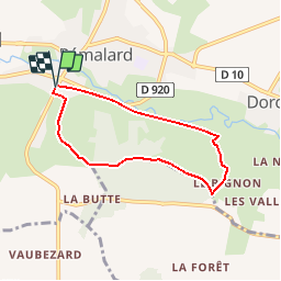
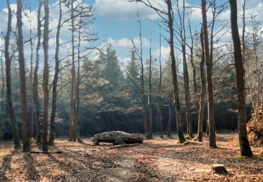
Trail Walking of 5.6 km to be discovered at Normandy, Orne, Rémalard en Perche. This trail is proposed by ODDAD78.
Description
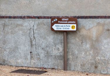
Les Boucles de la Voie Verte :
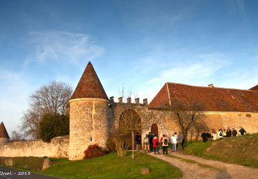
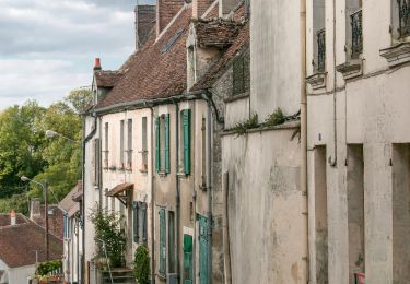
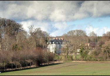
La voir Verte est une ancienne ligne de chemin de fer de 80Km (de Alençon à Condé-sur Huisne) réhabilitée en voie piétonne et cycliste. Je vous propose (en cours de construction) une série de petites randonnées en boucle qui comprenne un aller sur la (monotone ?) voie verte et un retour au point de départ par un autre chemin au coeur du Perche. La présente randonnée qui part de l'ancienne gare de Rémalard (parking) vous conduira sur les hauteurs du Bois Saint Georges d'où vous pourrez jouir d'un magnifique panorama sur la vallée de l'Huisne et ses collines. Bonne Rando sur les chemins du Perche ornais. ODDAD78
Positioning
Comments
Trails nearby
![Trail Walking Rémalard en Perche - La Nymphe du Perche 5,0 Km - Photo](https://media.geolcdn.com/t/375/260/17cc6b0d-b494-41c7-85a0-ede1466ba884.jpg&format=jpg&maxdim=2)
![Walking Walking](https://static1.geolcdn.com/sitytour/trail-icons/101.png)
Walking
![](/images/other/stat-length.png)
![](https://static1.geolcdn.com/siteimages/upload/files/16400158638029165_repeat_loop_refresh_sync_direction_icon.png)
![Trail Walking Rémalard en Perche - 2023-05-11_20h45m08_Randos 61 2023 3 Sur les terres du siège de Rémalard 9,5 km - Photo](https://media.geolcdn.com/t/375/260/4c079e8c-69f5-4bc5-9fc4-11ac01016a7e.jpg&format=jpg&maxdim=2)
![Walking Walking](https://static1.geolcdn.com/sitytour/trail-icons/101.png)
Walking
![](/images/other/stat-length.png)
![](https://static1.geolcdn.com/siteimages/upload/files/16400158638029165_repeat_loop_refresh_sync_direction_icon.png)
![Trail Walking Verrières - SityTrail - SityTrail - Les Vieilles Trognes 9 Km - Photo](https://media.geolcdn.com/t/375/260/2f52e433-da7f-4851-a063-0b8449b76186.jpg&format=jpg&maxdim=2)
![Walking Walking](https://static1.geolcdn.com/sitytour/trail-icons/101.png)
Walking
![](/images/other/stat-length.png)
![](https://static1.geolcdn.com/siteimages/upload/files/16400158638029165_repeat_loop_refresh_sync_direction_icon.png)
![Trail Walking Cour-Maugis sur Huisne - 12102996-Maison Maugis 22.37 - Photo](https://media.geolcdn.com/t/375/260/ext.jpg?maxdim=2&url=https%3A%2F%2Fstatic1.geolcdn.com%2Fsiteimages%2Fupload%2Ffiles%2F1553511878bg_sport_marche.png)
![Walking Walking](https://static1.geolcdn.com/sitytour/trail-icons/101.png)
Walking
![](/images/other/stat-length.png)
![](https://static1.geolcdn.com/siteimages/upload/files/16400158638029165_repeat_loop_refresh_sync_direction_icon.png)
![Trail Walking Rémalard en Perche - Nobles Logis du Perche (Rémalard) Variante 8,3 Km - Photo](https://media.geolcdn.com/t/375/260/8d898521-16be-4b88-87ed-874030b976e2.jpg&format=jpg&maxdim=2)
![Walking Walking](https://static1.geolcdn.com/sitytour/trail-icons/101.png)
Walking
![](/images/other/stat-length.png)
![](https://static1.geolcdn.com/siteimages/upload/files/16400158638029165_repeat_loop_refresh_sync_direction_icon.png)
![Trail Walking Cour-Maugis sur Huisne - Boissy-Maugis 8,4 km - Photo](https://media.geolcdn.com/t/375/260/b8f9aaa7-b59b-4d9c-ba02-624dc17d6137.jpg&format=jpg&maxdim=2)
![Walking Walking](https://static1.geolcdn.com/sitytour/trail-icons/101.png)
Walking
![](/images/other/stat-length.png)
![](https://static1.geolcdn.com/siteimages/upload/files/16400158638029165_repeat_loop_refresh_sync_direction_icon.png)
![Trail Walking Rémalard en Perche - Le ruisseau de Pontillon 11 Km - Photo](https://media.geolcdn.com/t/375/260/ff177aee-f1f8-438f-adec-36e6a48cd0c9.jpg&format=jpg&maxdim=2)
![Walking Walking](https://static1.geolcdn.com/sitytour/trail-icons/101.png)
Walking
![](/images/other/stat-length.png)
![](https://static1.geolcdn.com/siteimages/upload/files/16400158638029165_repeat_loop_refresh_sync_direction_icon.png)
![Trail Walking Rémalard en Perche - Nobles Logis du Perche (Rémalard) 24 Km - Photo](https://media.geolcdn.com/t/375/260/1e8cc532-bb5b-4a9b-8b5a-736f25271548.jpg&format=jpg&maxdim=2)
![Walking Walking](https://static1.geolcdn.com/sitytour/trail-icons/101.png)
Walking
![](/images/other/stat-length.png)
![](https://static1.geolcdn.com/siteimages/upload/files/16400158638029165_repeat_loop_refresh_sync_direction_icon.png)
![Trail Walking Cour-Maugis sur Huisne - La Clairière de Saint-Laurent 16,0 Km - Photo](https://media.geolcdn.com/t/375/260/5813c593-509f-42a8-97e4-39a0b1a6860f.jpg&format=jpg&maxdim=2)
![Walking Walking](https://static1.geolcdn.com/sitytour/trail-icons/101.png)
Walking
![](/images/other/stat-length.png)
![](https://static1.geolcdn.com/siteimages/upload/files/16400158638029165_repeat_loop_refresh_sync_direction_icon.png)
agréable